


VTD precinct 41, Grant County, South Dakota
About
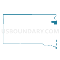
Outline

Summary
| Unique Area Identifier | 667309 |
| Name | VTD precinct 41 |
| County | Grant County |
| State | South Dakota |
| Area (square miles) | 109.66 |
| Land Area (square miles) | 109.48 |
| Water Area (square miles) | 0.19 |
| % of Land Area | 99.83 |
| % of Water Area | 0.17 |
| Latitude of the Internal Point | 45.06801410 |
| Longtitude of the Internal Point | -96.54993750 |
Maps


Graphs
Select a template below for downloading or customizing gragh for VTD precinct 41, Grant County, South Dakota


Neighbors
Neighoring Voting District (by Name) Neighboring Voting District on the Map
- Augusta Twp. Voting District, Lac qui Parle County, MN
- Mehurin Twp. Voting District, Lac qui Parle County, MN
- Nassau Voting District, Lac qui Parle County, MN
- VTD precinct 42, Grant County, SD
- VTD precinct 45, Grant County, SD
- VTD precinct 46, Grant County, SD
- VTD-precinct 1, Deuel County, SD
- VTD-precinct 2, Deuel County, SD
- Walter Twp. Voting District, Lac qui Parle County, MN
Top 10 Neighboring County Subdivision (by Population) Neighboring County Subdivision on the Map
- Alban township, Grant County, SD (580)
- Grant Center township, Grant County, SD (378)
- Vernon township, Grant County, SD (218)
- Adams township, Grant County, SD (150)
- Walter township, Lac qui Parle County, MN (148)
- Madison township, Grant County, SD (123)
- Revillo town, Grant County, SD (119)
- Augusta township, Lac qui Parle County, MN (110)
- Lowe township, Deuel County, SD (97)
- Georgia township, Grant County, SD (85)
Top 10 Neighboring Place (by Population) Neighboring Place on the Map
Top 10 Neighboring Unified School District (by Population) Neighboring Unified School District on the Map
- Lac Qui Parle Valley School District, MN (6,541)
- Milbank School District 25-4, SD (5,743)
- Ortonville -Bellingham Public School District, MN (3,549)
- Grant-Deuel School District 25-3, SD (970)
Top 10 Neighboring State Legislative District Lower Chamber (by Population) Neighboring State Legislative District Lower Chamber on the Map
Top 10 Neighboring State Legislative District Upper Chamber (by Population) Neighboring State Legislative District Upper Chamber on the Map
Top 10 Neighboring 111th Congressional District (by Population) Neighboring 111th Congressional District on the Map
Top 10 Neighboring Census Tract (by Population) Neighboring Census Tract on the Map
- Census Tract 9536, Deuel County, SD (2,924)
- Census Tract 9533, Grant County, SD (2,117)
- Census Tract 1802, Lac qui Parle County, MN (1,899)